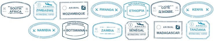
D1: Windhoek (43 km) |
| Meet and Greet |
| - | Be met at Windhoek Airport by one of our experienced guides, who will explain your itinerary and give you valuable advice, as well as information to make your trip run smoothly and be utterly unforgettable. Our guide will answer any questions you may have, hand over all the travel documents that you may need such as maps and vouchers, and escort you to your designated transportation. |
| - | Pick up your vehicle BRITZ(NA) Super Cover MSE: 7-20 Days at Windhoek - Drop Off Windhoek (Day 10) - 10 days (Optional rates: BRITZ MSE for 2 pax -SGL CAB)  |
| - | Pick up your vehicle BRITZ(NA) Super Cover DCE : 7-20 Days at Windhoek - Drop Off Windhoek (Day 10) - 10 days (Optional rates: BRITZ DCE for 4 pax- DBL CAB)  |
| - | Overnight: Villa Violet Bed (Standard Room - Bed and Breakfast) |
|
D2: Windhoek - Etosha (432 km) |
| Etosha Central Afternoon Game Drive(n) |
| - | Breakfast |
| - | Seize the last rays of the day on an afternoon safari in the Etosha National Park. As the sun starts making its descent towards the shimmering horizon, the animals converge upon the waterholes to quench their thirst. The central/southwestern sector of the park offers the best chances of seeing the endangered black rhino and lions attracted by the herds of zebra and wildebeest. The waterholes also draw a large number of elephant, particularly at the aptly named 'Olifantsbad', or 'elephants' bath'. (n) (n) |
| - | Overnight at the Camp site: Okaukuejo Rest Camp - Campsite (Camp site) |
|
D3: Etosha |
| Etosha Central Game Drive Full Day(n) • 4x4 Game Drive Half Day(o) |
| - | Sweep through the wilderness on a full day game drive in the Etosha National Park. Proclaimed a game reserve in 1907, Etosha spreads over 22 270km2 of saline desert, mopane forests and grassy scrublands. The park's most distinctive feature is the Etosha Pan, once a lake and now a massive white, salty depression that fills with pockets of pools after infrequent rains, attracting up to 1-million flamingos which use the pan as a breeding ground. The rain pools, along with approximately 30 waterholes and springs across the reserve, sustain an abundance of wildlife, including 340 bird and 114 mammal species, as well as some rarities like the Damara dik-dik, the black-faced impala and the Egyptian vulture. (n) (n) |
| - | Fulfil your African dreams with a half day Etosha National Park 4x4 game drive. Despite its arid, unusual setting, Etosha is renowned as one of the best game reserves in Africa. Enter the Von Lindequist Gate at sunrise and visit the numerous waterholes bordering the Etosha Pan, fed by springs and artesian fountains where you may encounter many species of animals such as black-faced impala, eland, giraffe, gemsbok, elephant, black rhino and lion. Covering almost a quarter of the park, Etosha Pan is the largest salt pan in Africa, supporting very little life except during the rainy season when up to 1-million flamingos converge on the pan. The smaller Fischer's Pan - named after the park's first game warden - also attracts thousands of flamingos and other waterbirds when the rains arrive. Stop at one of the rest camps for refreshments and observe the waterholes they overlook which in turn quench the thirst of the animals that they attract. Namutoni has a Beau Geste charm and the historic fortress was once the northernmost German outpost and is now a national monument. (Optional rates: J3:Etosha Central 4X4 Game Drive HD) |
| - | Overnight at the Camp site: Okaukuejo Rest Camp - Campsite (Camp site) |
|
D4: Etosha - Twyfelfontein (348 km) |
| Etosha Central Morning Game Drive(n) • Petrified Forest(n) |
| - | Plunge into the fresh outdoors on a morning safari in the southwestern sector of the Etosha National Park. Enter the park at the main gate in the south and spend the morning searching for Etosha's mammals along the vast salt pan and savannah woodlands. You'll come across troops of zebra and gnu on the grasslands dotted with mopane trees, and a variety of game quenching their thirst at the waterholes. Some of the forests shelter many rare bird species such as the blue crane, the secretary bird and the very rare Egyptian vulture. (n) (n) |
| - | Touch trees of stone with a visit to the Petrified Forest, a remarkable site of fossilised tree trunks dating back to the paleontological era. Geological research has revealed that these trees belong to the pine family, and were washed down the continent in a massive flood to their current site, buried beneath hundreds of metres of sediment. Over millions of years, the pressure caused the organic material to be replaced by silica and completely transformed the trees into stone. The effects of erosion have exposed these tree relics, including two trees measuring up to 45 metres. (n) (n) |
| - | Travel to Twyfelfontein |
| - | Overnight at the Camp: Madisa Camp (Camp site - Bed Only) |
|
D5: Twyfelfontein - Spitzkoppe (289 km) |
| Twyfelfontein World Heritage Site(n) • Spitzkoppe Conservancy(n) |
| - | Read the pictures that paint a thousand words at the site of Twyvelfontein in the heart of Damaraland. With over 2 500 rock engravings dating back 6 000 years to the hunter-gatherers of the Stone Age, as well as numerous Khoikhoi rock painting sites estimated to be 2 000 years old, Twyfelfontein has one of the largest concentrations of rock petroglyphs in Africa, and was declared Namibia's first World Heritage Site in 2007. The ancient engravings and paintings depict the lives of lost communities and the animals with whom they shared the landscape. Twyfelfontein is translated to 'doubtful spring' in Afrikaans, referring to the /Ui-//aes spring that that lies within the valley along the slopes of the sandstone plateau. (n) (n) |
| - | Travel to Spitzkoppe |
| - | Take on the challenge of the Spitzkoppe, Namibia's most well-known mountain owing to its beautiful rock formations. Located between Usakos and Swakopmund, this pointed granite mountain - the legacy of a collapsed volcano - rises from the middle of the Namib Desert to a height of 1 728 m. The Spitzkoppe is popular with campers and hikers, as well as mountain climbers as the sheer granite cliffs present a very challenging climb. At sunrise and sunset, the mountain is at its most beautiful, the burnished shades contrasting with the bright blue sky. This site is also renowned for ancient San rock paintings. (n) (n) |
| - | Overnight at the Camp site: Spitzkoppe Rest Camp - Campsite (Camp site) |
|
D6: Spitzkoppe - Swakopmund (290 km) |
| Cape Cross Seal Reserve(n) • Swakopmund Orientation(n) |
| - | Travel to Cape Cross |
| - | Watch as seals frolic on the shores of the Cape Cross Seal Reserve. Located approximately 60 km north of the coastal city of Henties Bay on the Skeleton Coast, this reserve holds the largest breeding colony of the Cape fur seals in the world. Cape Cross is also where Portuguese explorer Diego Câo erected a stone pillar and cross to establish his claim on the territory in 1486. The original cross was removed in 1893 and taken to Berlin after the German possession of the land, and a replica made of Namibian dolomite was erected in its place. The reserve is open daily from 10am to 7pm. (n) (n) |
| - | Travel to Swakopmund |
| - | Soak up the salty sea breeze on an orientation tour of Swakopmund. A popular seaside resort providing visitors respite from the heat of the desert, the town is a quirky mix of German architecture, stemming from its origins as a harbour town for German South West Africa, and the African love for adrenalin. To this day, the town's main inhabitants and visitors are German-speaking, preserving European heritage at the edge of the Namib Desert. The harbour activities were moved to Walvis Bay in 1915 but tourism continues to thrive as visitors come to see the incongruous Baltic Sea architecture among palm tree-lined streets, and participate in the plethora of outdoor activities on offer. The most iconic remnant of the German colonial era in Swakopmund is the ornate Victorian Hohenzollern building, dominated by a figure of Atlas holding the world upon his shoulders. Other prominent examples of German architecture dating from the early 1900s include the Prinzessin Rupprecht Rezidenz (originally a military hospital and now a hotel), the Woermannhaus (1905), the youth hostel, the Lutheran Church on Post Street (1911), the court, the railway station which is also now a hotel (1901), the buildings on Sam Nujoma Avenue (previously Kaiser Wilhelm Strasse), the Arnold Shad Promenade, and the metal pier which was built in 1915, and recently rescued from dereliction. (n) (n) |
| - | Overnight: Villa Maji (Superior room - Bed ad Breakfast ) |
|
D7: Swakopmund - Namib-Naukluft (349 km) |
| Moon Landscape and Welwitschia Mirabilis(n) • Kuiseb Canyon(n) |
| - | Breakfast |
| - | Travel to Namib-Naukluft |
| - | Walk on the moon Namibian-style at the Namib Moon Landscape, a name given to a part of the valley of the Swakop River near Swakopmund. The lunar-type landscape, eroded by thousands of years of wind and rain, is awe-inspiring. The river that flows from time to time at the bottom of the valley brings a short-lived period of fertility to the region and the water allows some plants to survive in this hostile environment. Man tried to cultivate parts of this valley for agriculture at the beginning of the previous century, with little success due to the harshness of the environment. Discover the Welwitschia mirabilis, a botanical curiosity that is found almost exclusively in areas of fog of the Namib Desert. Some specimens are older than 1500 years. (n) (n) |
| - | Capture hypnotic scenic images at the Kuiseb Canyon. The ephemeral Kuiseb River has carved an impressive nine kilometre long canyon which can be seen from the C14 road close to the town of Solitaire. This river is the dividing line between the endless rocky plains of the north and the sand dunes that end near the Orange River. After the rainy season in the summer, the Kuiseb River mostly dries up but some water remains at the canyon. Klipspringer, leopard, hyena, jackal and springbok can sometimes be spotted. (n) (n) |
| - | Travel to Namib-Naukluft |
| - | Overnight at the Camp site: Sesriem Camp - Campsite (Camp site) |
|
D8: Namib-Naukluft |
| Sossusvlei and Deadvlei(n) • (n) |
| - | Spend a full day in the desert to see Sossusvlei and Deadvlei. Drive to the entrance of the national park at Sesriem. From the entrance, continue along a paved road for 50 kilometres and be mesmerised by the transition between the magnificent landscapes of the Naukluft mountains and those of the dunes. If you’re up to the challenge, you can climb Dune 45, the real star of the show, and probably the most photographed dune of all. Arriving at the car park signalling the end of the asphalt road, you can continue your way on the sand for 5 km provided you have a 4x4, or take the shuttle to the car parks serving the sites of Deadvlei and Sossusvlei. A few hundred metres’ walk in the dunes from the parking of the site you will discover Deadvlei, a clay bowl sheltering a dry, cracked lake. The contrast between the blackened trees, the white of the lake, the ochre of the dunes and the deep-blue sky is dazzling. Finally, discover the incredible site of Sossusvlei. All the splendour of the Namib is concentrated here. From the top of one of the dunes, a breathtaking sea of sand awaits you, filled with giant dunes, the highest in the world, some reaching 300 metres in height. (n) (n) |
| - | (n) (n) |
| - | Overnight at the Camp site: Sesriem Camp - Campsite (Camp site) |
|
D9: Namib-Naukluft - Kalahari (305 km) |
| Kalahari Visit(n) |
| - | Travel to Kalahari |
| - | Be blown away by the haunting beauty of the Kalahari Desert. Extending over an area of 500,000 km², the Kalahari covers most of Botswana - where it is known as the Kgalagadi - some areas of South Africa, and south-eastern Namibia. Contrary to what the notion of 'desert' might suggest, the Kalahari has a semi-arid climate and receives an average annual rainfall of 100 mm (as opposed to a maximum of 25 mm for a true desert). The rains enable a multitude of life to flourish across the red sands that transform into grassy plains at times of higher rainfall, and numerous species of mammals and birds inhabit the Kalahari, as do the San Bushmen, southern Africa's oldest human inhabitants. The solitary expanses evoke a sense of isolation, yet its lunar landscapes, varied fauna and flora and ancient tribes make the Kalahari an enriching experience. (n) (n) |
| - | Overnight at the Camp site: Kalahari Anib Lodge - Campsite (Campsite ) |
|
D10: Kalahari - Windhoek (281 km) |
| Khomashochland(n) |
| - | Travel to Windhoek |
| - | Travel through Namibia’s bounty of nature at Khomas Hochland. This area forms part of Namibia’s central plateau and is an integral part of the Great Escarpment that cuts the country in two. It covers a region of approximately 180 kilometres and reaches an altitude of 2 000 metres before dropping by a sheer 1 000 metres to the west. The scenery here is strikingly beautiful and the area is well stocked with plains game such as oryx, kudu, zebra and waterbuck as well as baboon and warthog. Two seasonal rivers, the Aretaragas and Otjisevas, tear through the rocks, creating impressive gorges and a water paradise for many varieties of birds that can also be viewed in abundance at the river dams. Bird diversity in the landscape is high and includes many of Namibia's endemic bird species such as Rüppell's parrot, Monteiro's hornbill, rockrunner and white-tailed shrike. (n) (n) |